Tuesday, January 31, 2012

A New Image for Lillestrøm


This project is about transforming infrastructure through an investigation of mobility and streets in cities. The project aimes to provide critical insights into the conversation about future mobility as well as street quality. It is easy to argue against the car and the development occurring worldwide, but the important question is how streets can improve the quality of our life.

The future holds the possibility to rethink streets and their role. What can the street perform and how can it interact with its users? Our streets should be safe. They should also be able to transport more people, collect and treat water in natural systems, contribute to social interaction and perhaps even provide food? They are vital in creating healthy sustainable cities. To establish a sense of connection and respect for your surroundings, speed must also be taken to consideration. The faster you travel the greater the loss of connection to your surroundings. When getting inside a car, time and space become distorted. In terms of mobility, choice must also be offered to people.

Thousands of zero-emission vehicles are emerging, and it is therefore vital to design flexible and adaptable streets to gain maximum efficiency. We must prepare our infrastructure for the future. Can the infrastructure be designed in such a way that it is capable of having multiple modes of transport interchanging, possibly changing over time, without losing the quality of the space?


Lillestrøm is a town of 15,000 inhabitants and is situated 6 km out of Oslo. It has a unique shape, being place on a riverplain between two rivers, Nittelva and Leira.
Lillestrøm is in Skedsmo municipality, with 49,000 inhabitants, placed between Oslo City and Gardermoen Airport.


The streets in Lillestrøm are based on a grid system and mostly consits of one family houses with big gardens, carefully marked and closed. The difference between what is privat and what is public in these spaces is clear.

Mapping Lillestrøm
I mapped the width of all streets in Lillestrøm and compared it to other data to try to figure out the logic behind the system. I mapped national roads going through Lillestrøm, speed limit on all streets, traffic volume, parking and open green areas. I discovered that there is no one rule deciding the width of streets in Lillestrøm. Multiple things have to be taken to account. The street width is sometimes related to density, other times to traffic volume as well as speed limit.


Future scenario


Lillestrøm is a city with grid based street network, and in my project I propose that the qualities of the grid are maintained and enhanced, with opening up one way streets and reconnecting cut off ends. That way the full potentials of an open grid network are exploited. I also propose that most of the streets will be narrowed, except in the city centre, as a sort of a ‘reverse Haussmann’. To enhance to quality of the space in the city, the streets are made narrower, and by doing that I also aim to increase the permeability of the surface as well as increasing biodiversity. At the same time I develop a typology for shared streets in the villa neighbourhoods. To spatially connect private gardens to the public street strengthens the spatial quality as well as safety of both. I propose that the speed limit for Lillestrøm will reduced down to 30 km per hour and in the villa neighbourhoods, down to 15 km per hour. This increases the safety enormously and opens the possibility of intergrating streets better into other spaces in the city. Driving from one end of Lillestøm to another, at this reduced speed limit is only increased by 4 minutes from todays situation.


Redesigning the Streetscape


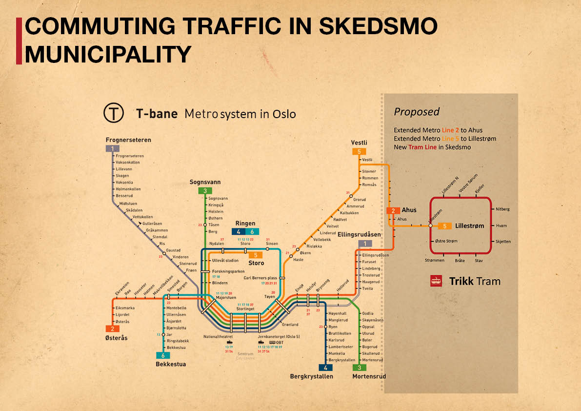
Finally I propose the city centre expansion and future densification to follow Alexander Kiellands gate - a big and beautiful esplanade that goes from existing city centre, capable of supporting much higher density than today’s situation. The esplanade is well suited for the new tram line I propose, to connect the scattered development in the municipality. That tram line then has the possibility to connect to Oslos Metro system, addressing the problem of commuter traffic in the municipality.


To go in this direction could take us down a safer, healthier and more efficient path, towards sustainbility, and would develop a new image of Lillestrøm as a more livable city, with a much greater potential to meet tomorrows challenges when it comes to transport.
Sigurborg Ósk Haraldsdóttir, Autumn 2011

Thursday, January 5, 2012

Transforming Road Infrastructure in Cities

People meet on the on horizontal surface between buildings. The inhabitants of a city are forced to meet, having never seen each other before and maybe never to do so again, on the street. People interact and communicate according to preconceived rules defined by whatever they are sitting on, walking with, riding on or driving in. Still, communication between one riding a bike and another driving a car can be difficult and easily misinterpreted. It has been proven that removing traditional road markings, signs and traffic signals actually increases the safety in a street and that building more roads, actually creates more traffic (Vanderbilt, 2008). This is inconsistent with most of the development and current situation in streets today, so one wonders, what is the best way to go? The World Health Organization predicts that by the year 2020, road fatalities will be the world‘s third-leading cause of death. Do we really want to go down that road?  


It is interesting to see how the role and function of the road has changed over time for better, or, as in most cases, for worse. One example is Parramatta Road in Sydney. Julian Raxworthy (Topos 75, 2011) writes in his article, `Parramatta Road: infrastructure as opposite of growth`, about Parramatta Road which started as an indigenous track through the bush and transformed to become a road for horse-drawn carriages, then to a muddy road for cars and finally to a sealed, multi-lane arterial road. The road has grown bigger and bigger, and is now suffocating everything in its immediate surroundings with noise and pollution. The city of Sydney plans to address this problem by putting vehicular traffic on Parramatta Road into a tunnel.


New York City has a similar story. In the 1900s New York had streets full of social, physical and economic activities. The street had a multifunctional purpose and was vibrant with people of all ages working, playing and socialising (DOT, 2009, p.18). Obviously there were also a lot of problems in the streets at that same time. Sanitation, safety, water systems and mobility in the city were all in poor condition.


Today these issues have been addressed, but the way they have been treated and the development occurring as a result has created a variety of other unanticipated problems. This occurs in many places all over the world. For example, channelling various forms of water runoff, such as sewage, storm water and natural rivers, into the same pipes beneath the urban surface, can in times of heavy rainfall, create an unstable condition, vulnerable to flooding. This is especially significant in a time of climate change, where rainfall patterns are changing and urban water cycles are increasingly interrupted.

After the motorcar was introduced to New York City, it became more and more dominant. The car squeezed out other transportation alternatives and increased noise and dust pollution, along with greenhouse gases (DOT, 2009, p.19). Today the city is implementing more sustainable projects that are focusing other modes of transport such as bicycles, public transport and pedestrians, with the hope of bringing city life out into the streets again.


A similar story can also be observed in Paris. During the 19th Century Paris had a lot of problems regarding sanitary, water systems, traffic congestion, and safety for its inhabitants. In certain slums the population density reached 100,000 people/km2 and rebellions were common. In the 1860s a radical transformation of the city began, led by a French planner named Baron Haussmann (Jordan, 1995). Most of the wide, long and straight boulevards, which today are the well-known and loved image of Paris, are Haussmann‘s work. His reconstruction, or cleaning as he himself called it, was superimposed onto an old and complex street network from the Middle Ages, a network made out of narrow, meandering streets and houses cramped next to each other. The main strategy was to build multifunctional wide streets, over 30 meters wide, the widest street in Paris at that time being 13 meters wide (Jordan, 1995). Haussmann gave large spaces to pedestrians that created a new type of urban scenario, which saw cafés and shops thrive in the streets. By doing this Haussmann succeeded in creating safer streets with better sanitary and consumer-friendly communities. He was also solving traffic congestions at this time, which were of a different nature than the ones troubling Paris today. In his reconfiguration of the Paris, Haussmann had over 20,000 houses removed and more than 40,000 new ones built (Jordan, 1995). His boulevards are today the backbone of Paris‘s city structure.


Today, however, Paris faces omnipresent traffic jams of an enormous scale , except at night-time and mid-summer. Haussmann’s boulevards are crammed with traffic (controleradar.org, 2010) continuously from the city centre to the outer regions. Famously, France holds the record for the world’s longest traffic jam, which streched 176 km from Lyon to Paris (Guinness Book of Records, 2012). 

It is clear that, over time, the streetscape has lost many of its qualities and this is the case in many parts of the world. An example of a quality lost is the human scale. We are facing serious problems on both the small and the big scale in our cities that urgently need our attention. Perhaps we should consider the non-linear way natural systems work and perform, as they can be a big inspiration in rethinking and preparing our cities for the unknown future.


Mark Tyrrell talks about ecological system connectivity in his article `Future Urban Visions; from Sydney‘s fleeting past` (Topos 75, 2011). He says that Sydney previously had a balance between development and natural systems, a balance that should regained if we are to live in harmony with nature and to deliver this planet to future generations. Elements in our future cities could hold a powerful sense of local place by reintroducing nature and ecology into our cities, woven through and around the urban fabric with clean streams and local flora and fauna.


Raxworthy thinks that the tunnel for Parramatta Road will be abandoned before it is finished and the reason, he argues, is climate change. Contemporary research by specialists, professors and international institutions agrees. We have to abandon fossil fuels completely, possibly within the next twenty years (Gilding, 2011). If this is correct, streets and other spaces devoted to the car are areas which will have to drastically transform in the future, and untold opportunities for new and unknown uses lie within the space of our current streetscapes.


Sigurborg Ósk Haraldsdóttir
Student - Master of Landscape Architecture Program
AHO Arkitektur- og Designhøgskolen i Oslo
The Oslo School of Architecture and Design


Bibliography


Controlerader.org (2010), Traffic jams on French roads: when and where, http://english.controleradar.org/traffic-jam.php, viewed 16.12.2011.
New York City Department of Transportation, DOT (2009), Street Design Manual, Vanguard Direct, United States.
Gilding, Paul (2011), The Great Disruption, Bloomsbury, London.
Guinness World Records (2012) Guinness World Records 2012, Guinness World Records, United States.
Jordan, David P.  (1995), Transforming Paris: the life and labour of Baron Haussmann, The Free Press, New York.
Raxworthy, Julian (2011), Topos 75  Sydney- London- New York, Callway, Germany.
Tyrrell, Mark (2011), Topos 75  Sydney- London- New York, Callway, Germany.
Vanderbilt, Tom (2008), Traffic, Penguin, England.


Monday, January 2, 2012

In the beginning

This blog is created by me, Sigurborg Ósk Haraldsdóttir, a student doing my diploma in Landscape Architecture at AHO, The Oslo School of Architecture and Design. I intend to use this blog to post my ongoing work and ideas.